Extreme heat is deadly. In fact, dangerous heat is more fatal than hurricanes, floods and tornadoes combined, Scientific American reports. Add to that the fact that 2023 was the hottest year on record — and 2024 is expected to provide another scorching summer for the history books — and it’s plain to see: Humanity has good reason to sweat.
Because it may be the primary reason for Earth’s continual warming, it has become essential for policymakers to monitor and understand climate change. Armed with the right climate data, they just might be able to cool things down before it’s too late.
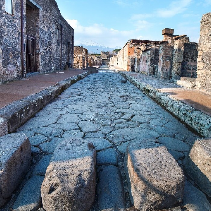
Their swift intervention is especially important in cities, where rising temperatures are most pronounced thanks to asphalt roads, tar-covered buildings and sparse vegetation.
“Urban heat islands are definitely a contributor towards climate change,” said Keenan Gibbons, a licensed landscape architect and urban design professional who specializes in green infrastructure, parks and streetscapes.
To understand urban heat islands, and hopefully reduce their impacts, Gibbons and other scientists like him are turning to an interesting tool: thermal imaging drones that can map rising urban temperatures.
“The goal is to identify what’s causing the heat, so it shifts the green conversation from a qualitative discussion toward a quantified one,” Gibbons continued. “Now people can see what is occurring and why. It’s raising awareness to ultimately shape climate change policy and … make cities more resource-efficient.”
Hot as Hades
Drones already are being used to detect and stop wildfires. Now, Gibbons and his colleague, Salvador Lindquist, are using flying camera drones to study how heat impacts American cities at a localized level. Their findings could be key to making dense communities more livable in an increasingly warmer future.
“The comparative temperature difference between underdeveloped green space compared to manmade structures within a city is known as the urban heat island effect,” Gibbons said. “The effect makes cities comparatively hotter, often upwards of 10 degrees or more [compared to] undeveloped areas. It started back in 2003 with the European heat wave that caused 70,000 deaths. That’s where the heat island effect really gained its notoriety because it is directly linked to human mortality, especially with at-risk or marginalized populations.”
Drone innovation is helping Gibbons and Lindquist gain insight into how heat plagues the built environment and threatens the wellbeing of urban residents.
“The camera takes a photo in RGB color at the same time as it takes an infrared thermal image of the exact same place,” Gibbons said. “If you have color and thermal images side by side, you can really see what’s causing the heat. It’s a really powerful tool, as we can get accurate surface temperature readings.”
Thousands of photographs later, researchers are able to build a half-mile-long 3D model of a specific stretch of city streets. With the help of the cloud, they can process terabytes of image data in order to construct these color and thermal maps faster than ever before.
“Traditionally, it’s been dependent on your own machine,” Gibbons said. “To do a 2,200-image photogrammetry process would take many hours. Now with the cloud, it’s just incredibly fast.”
Never before have city planners been given temperature data with such incredible detail.
“The resolution that we get from a drone is much greater than a satellite,” Gibbons continued. “It allows us to quantify and really dial it in with a lot more granularity. Satellites fly over 400 miles above the sky, whereas with the drone you can’t fly more than 400 feet above ground level — so we’re just that much closer. I’m not waiting on the satellite to fly by. I can do it whenever I want to. The 30-meter-by-30-meter resolution of a satellite can’t compare, because when you zoom in on that, it’s not that clear and it’s not helpful at a human scale. For comparison, the resolution of a UAV thermal camera is about a centimeter per pixel.”
Some of the temperatures that they measure with this set-up are shocking, often clocking in at 160 to 170 degrees Fahrenheit.
“I always compare it to meat,” Gibbons explained. “Your steak or your burger is considered rare at 120 degrees, medium at 140 and well-done at 160, so we’re really cooking these vast swaths of our cities well-done.”
Beating the Heat
As the project expands and the duo continues to map more neighborhoods across the United States, their aim is to contribute to the larger conversation and help mitigate the effects of climate change.
According to Gibbons, that solution involves choosing building materials with less emissivity and planting trees or constructing structures that provide additional shade throughout the cityscape.
“It’s shade that can be achieved by trees or buildings and material choices, too,” Gibbons said. “There are new admixtures for pavement being explored that don’t absorb that much heat. If you have vegetation, that’s changing the surface cover from something that’s very hot and dark towards something that we all enjoy. It’s just aesthetically more pleasing and thermally more comfortable.”
Their studies could also help transform how future construction is done in the age of climate change.
“The research allows us to reorient the way we do urban design towards a more thermally sensitive palette of materials than we’ve done in the past,” Gibbons said. “We’ve created this situation with our material choices of the past half-century or more. This is becoming more paramount because cities are growing and the population is still going up, so there’s going to be more development. We’re going to start seeing certain materials having restrictions based on how they perform thermally, reshaping the way things are done in development. When we do these infrastructure projects, they present a great deal of permanence, as they last a half-century or more. So we have to make better decisions before it occurs, and this data helps us do that.”
Clearly, everyone must work together to solve the challenge of rising global temperatures. Doing so will not only make cities more comfortable during the next inevitable heatwave but also save lives.
“This past summer was the hottest on record and we keep setting new records,” Gibbons concluded. “My research partner and I talk about how this is the coolest that we’ll ever see Earth again. If it’s going to get hotter, then anything we can do to help is a good thing. Why are we accepting so little when we can do so much just by changing our decisions?”
Chase Guttman is a technology writer. He’s also an award-winning travel photographer, Emmy-winning drone cinematographer, author, lecturer and instructor. His book, The Handbook of Drone Photography, was one of the first written on the topic and received critical acclaim. Find him at chaseguttman.com or @chaseguttman.
© 2024 Nutanix, Inc. All rights reserved. For additional information and important legal disclaimers, please go here.