Topsoil is displaced and disappearing at an alarming rate. That rate is accelerated up to 50 times by human activities, according to some reports. Unsustainable farming practices, deforestation, urbanization and climate change are a combined threat to the dirt essential for food production.
Topsoil is the most productive part of the soi. It is full of nutrients. Major signs of damage from soil erosion are clearly evident and spreading around the globe. Some estimate the U.S. could run out of topsoil in 100 years or less, putting some 9 billion people at risk of starvation in 2050.
Increasingly, scientists like Dr. Bradley Miller believe it will take real-time data analysis to manage soil erosion.

In this Tech Barometer podcast segment, Dr. Miller takes listeners out to Iowa farmland. He explains how his lab at Iowa State University – the Geospatial Laboratory for Soil Informatics – is using new IT tools such as cloud, AI and remote sensors to better understand topsoil movement across 26 million acres of his state’s farmland.

Transcript (unedited)
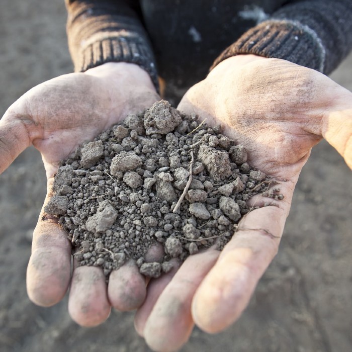
Bradley Miller: The soil here. You actually see how it's cracking and that's actually an indication of higher clay content. So we're still studying more about how particle sizes are sorted down the hill slope, but we certainly know that there's gonna be more clay, uh, towards the base of the slope than the top of the slope.
Jason Lopez: Dr. Bradley Miller oversees the geospatial laboratory for soil informatics at Iowa state university. Today he's on Iowa state research farmland, just outside of Ames, Iowa, to show how topsoil migrates down, even gentle slopes in his research. He wants to know how soil particles move a quick of major importance as the world loses topsoil. The UN's food and the agricultural organization says due to conventional farming techniques, the earth could lose its topsoil by 2080 Miller uses a soil sampler probe, which he pounds into the ground to pull out a core sample of soil layers

Bradley Miller: By a couple of things you notice it's much more black than it was at the top of the hill, but also it's staying black as I'm going deeper and actually you can see a little bit about the soil structure here. So these little crumbs here, we call them pets. And with organic matter, basically, that's partly what makes a good soil structure here. So the more organic matter you have and the more granular structure you have, that's better for holding the right amount of moisture. And so that's an interesting question as we think about having the organic matter in the right place. So when we talk about carbon sequestration and carbon credits, it actually works pretty well for storing carbon to have it buried down here because deeper it is more locked into the soil is, but the problem is that all that area upslope, if it doesn't have good organic matter, that's gonna affect, um, how well the crop grows.
Jason Lopez: The idea of topsoil loss is not new at the local level. Farmers have witnessed it happening on their land for ages.
Bradley Miller: So locally, if I have, uh, a single field that covers a hill slope, I'm gonna be thinking about, okay, how do I management practices affect the distribution of the quality soil in my field, but at the same time, um, because these things are interacting at the large regional scale, both how it interacts with climate, um, how we have certain incentives from the government to implement certain management practices. Um, so you think about, you know, feeding a lot of people, uh, we do kind of need the, the bigger picture as far as you know, well, how, how, how full is the gas tank for what we can get from the landscape and thinking about how do we, we keep it at a level that helps that bigger picture, get the amount of food that we need.

Jason Lopez: Getting the bigger picture is what Miller's research is all about. It's one thing to get a core sample at the top of a slope, walk down the slope and get another core sample and determine how much soil has moved down the hill between those specific points. But what's happening with soil movement on another part of the slope over the span of an acre or a county or an entire agricultural region that would require massive numbers of survey points. The question is how to get millions of these, not just once but many times over time to understand how soil is eroded over large areas of farmland. Miller says at the heart of this is a geomorphology question.
Bradley Miller: What we really become interested in geomorphology is how does the shape of the earth changes over time by understanding the geomorphology processes, we're able to develop models where we can start asking questions about how is the soil-landscape gonna change in the future?
Jason Lopez: Geomorphology encompasses the study of the shape of the earth from sand dunes to mountains, to the land used by
Bradley Miller: Agriculture. We have several different angles by which we've come at the erosional landscape and how the landscape evolves, whether it be models that really look at how the shape of the L changes or from the soil side, looking at rates of erosion far as the volume of soil that is getting moved and eventually delivered to waterways. The challenge though is that we haven't had the opportunity to really have observed data that check those models in the long term. LIDAR technology gives us the opportunity cuz Iowa will be one of the first states to have wide area coverage of LIDAR repeated over 11 years. That gives us the opportunity to check those models and then try to improve those models so that we can actually have confidence in predicting a real future.

Jason Lopez: LIDAR stands for laser imaging detection and ranges by measuring the return of laser light. The technology can create 3d maps of the earth from above, usually from airplanes. It's a critical tool for scientists studying geology, earthquakes, forestry, and many other disciplines and car makers use it in navigation systems in autonomous vehicles to detect and avoid objects. But in Miller's research, he's using LIDAR data, to determine the micro changes in altitude of the rolling Hills in Iowa carpeted with corn and soybeans. It tells him how much topsoil is being lost. As it moves downhill on a long march to the Gulf of Mexico.
Bradley Miller: When we see the difference in elevation from 2009 to 2020, we can say, okay, we observe this amount in of elevation change. And then the question is, can our models starting with 2009 as the baseline, will they actually predict what happened in that 11-year span?
Jason Lopez: If Miller's research can show the model's work, it could have enormous implications for understanding how to preserve the topsoil. The world needs to grow food. What was once humanly impossible to measure in this case? Massive numbers of survey points on 30 million acres of Iowa farmland is now doable.
Bradley Miller: So you cover a large area with that. That's a large amount of information. And then that gets multiplied by the time steps that we're looking at, just the validation data being 2009 and 2020 for the project we're doing here in Iowa. That's basically the state of Iowa double over, but as our models make predictions about the different landscape changes over time. Each of those time steps is another representation of the whole area, Iowa, with that amount of detail. So the amount of data gets multiplied by
Jason Lopez: All that, with the technology cocktail of LIDAR cloud and AI Miller and his team are able to see soil properties on a scale, never seen before LIDAR can see the surface changes of soil loss, but it can't see below to the layers expos, as we witnessed earlier, by pounding in a soil sampler to pull out a core, but that's where AI.
Bradley Miller: Can help out. We see relationships with some of the things that are on the surface with what happens below and finding those patterns is really where machine learning comes into play. And then we're going to process models to basically predict what's gonna happen over to time.
Jason Lopez: Professor Miller emphasizes that this work is still ongoing, but the addition of sensing and information technology tools to scientists puts them much closer to understanding the dynamics of topsoil from farm fields of Iowa, to the rest of the world
Bradley Miller: In science, we frequently have this idea that you hold a candle up in a dark room. You can see the light around that, and that's the world you see, but as you increase the brightness of that candle, the world gets bigger. And it's kind of a similar story for a lot of things that we're exploring, whether it be black holes or the human brain, or even soil as we're getting new tools, we have new ways of looking at it and digging pun intended deeper into it. It far as I understand what's happening, the one extra piece maybe for soil is that as you look across the landscape, the soil's different all over the place. There are similar processes happening, but the interactions are happening in different ways. And now I'm gonna show you the difference between the soil on top of this hill, to the bottom of the hill, but go to other Hills, there's gonna be things that are similar, but so different understanding all of that spatial variability is part of the challenge in fully understanding soil
Jason Lopez: Bradley Miller is a soil scientist and head of the geospatial lab for soil informatics at Iowa state university. This is the tech barometer podcast produced by the I'm Jason Lopez. If you like this story, you might want to check out our other forecast stories on technology and science at www.theforecastbynutanix.com.

Jason Lopez is executive producer of Tech Barometer, the podcast outlet for The Forecast. He’s the founder of Connected Social Media. Previously, he was executive producer at PodTech and a reporter at NPR.
© 2022 Nutanix, Inc. All rights reserved. For additional legal information, please go here.